The Firth of Lorn
- Apr 9
- 13 min read
Updated: Apr 11

When I was down beside the sea
A wooden spade they gave to me
To dig the sandy shore.
My holes were empty like a cup.
In every hole the sea came up
Till it could come no more.
Robert Louis Stevenson
A Child’s Garden of Verses
It is a well-known fact that no-one in Britain lives further than 70 miles from the sea. Nevertheless many of us are happy to know no more of how our tidal edge works than that the sea comes in, and then it goes out.
I lived right by the sea for much of my childhood and spent plenty of time messing around in boats but had always been resistant to learning more. And then, one day, that changed. My one desire was to paddle my own kayak and go exploring. I would have to start learning.
In June, 2019 Alan Kimber chartered Murdo’s boat to take us all to St. Kilda, the western-most archipelago in the UK, 40 miles into the North Atlantic from Harris in the Outer Hebrides. Amy and I felt very lucky to be there.

Photo by Colin Baxter
The journey from Leverburgh on Harris was unforgettable: big sea, whales slicing through the silky backs of green rollers. So close you could stroke them. A pilot whale and, later, several Minkies.

As we drew closer to the islands dolphins shared our wake. In the approach to Hirta, tight between the giant rocks, we were in a kingdom of majestic gannets spiralling in columns above white breakers.

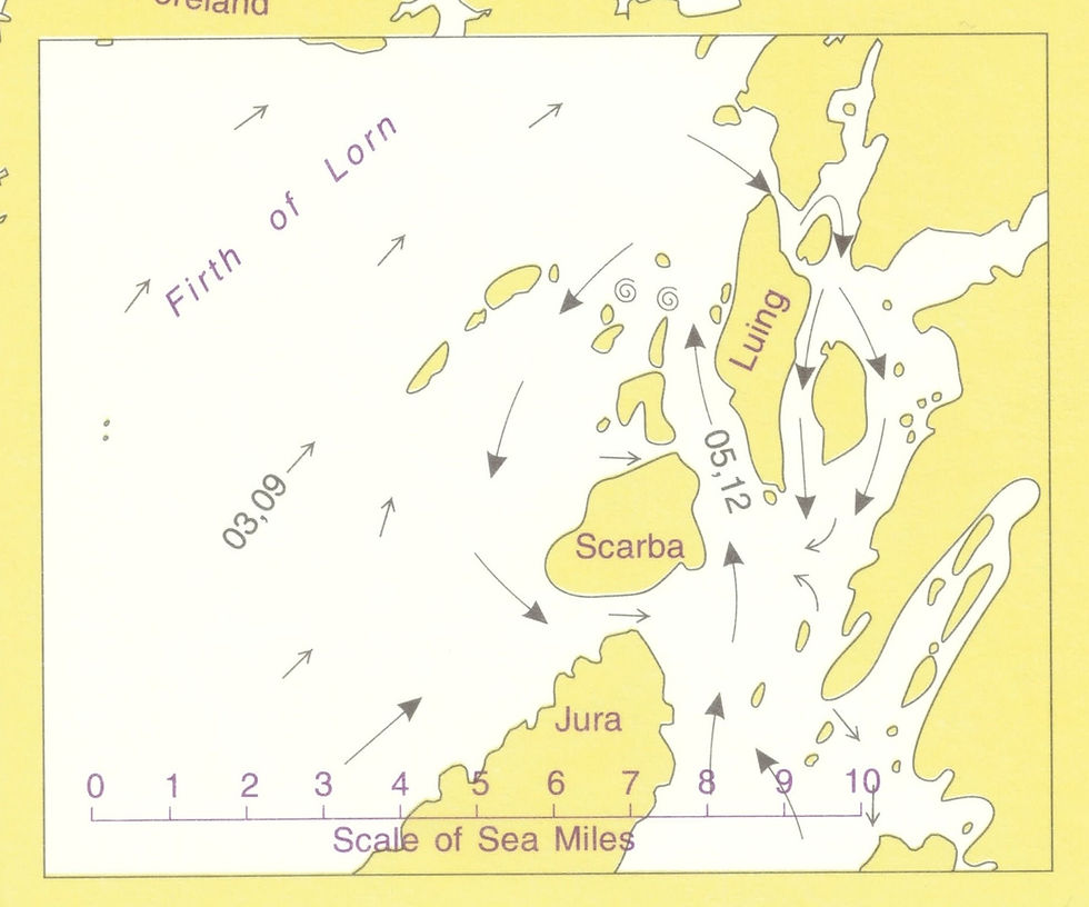
One evening Alan Kimber remarked that in his opinion the Firth of Lorn was hard to beat as a sea kayaking destination. Nick and Alan held forth with tales of journeys made and islands visited. Places to dream of. Some dreams will come true, later.
Amy and I sat with our ears neatly pinned back. Magic yarns unspooled between the two of them. Some places scary. Somewhere called the Grey Dogs. At the Gulf of Correyveckan, “the cauldron of the speckled seas”, my ears closed down..
“Where is the Firth of Lorn?” I ask, by way of diversion.

Admiralty Chart. Scotland West Coast, 2365
“Well,” said Alan, getting up to draw an imaginary line on the chart that covered most of the wall, “It's here. The thing about it is, the thing to remember is that you could be here, east of Luing and the flow wouldn’t be much to worry about, but just over here, in the Cuan Sound, well it’ll be as much as 6kts west to east. But on the ebb, say you’re going south in Shuna Sound it’ll be around 2kts which is ok. You really want to know what you’re doing and over here…but of course, over here, is the Correyveckan… do you remember Nick?”

Sue Kimber, who has been listening with a gentle, inscrutable smile raises her eyebrows, just for a moment. We’re getting ominously close to the scary stuff again so I asked the only question you need when you have Nick to hand:
“Why? How does it work?”
And that’s how we came to be treated to a Nick Hall masterclass on tidal flow.
I had already started learning how to navigate. I’d done a course or two. I’d read and re-read the kayaker’s bible: “Sea Kayak Navigation” by Franco Ferrero. I'd even made a navigation notebook with the help of my grandchild Morgan.
+ella pic

A Complete Treatise on Navigation with lively additional illustrations by Morgan, aged 5.
I made my navigation notebook to help my memory. When I was 5, or 15, or even 25 I didn't need to. I laboured over every detail, thinking I needed to remember what colour cones are marking the edges of shipping lanes and how many minutes there are between the lines. In the end I remember what I need to. I hope. But the great unexpected thrill at 75 is learning.
I had started to plan every trip I went on, and some I didn’t, just for practice. A good friend, Dave Butler, had checked my work and partner Col had explained that the tidal flow, out on open water, can be described by a sine wave.
There were plenty of sums and reckonings which I find challenging but most of those early trips had the tidal flow going this way for roughly 6 hours and then that way for 6 hours. That’s because my first playground was the Welsh Coast, the Lleyn Peninsula, Cardigan Bay. You just work out which way the flow is, what speed it will probably be running at any given time, allow for wind and swell and Bob’s your Uncle.

Diagram from Welsh Sea Journeys by Jim Krewiecki and Andy Biggs
There are exceptions. In the Menai Straits the tidal stream comes from each end and meets in the middle, and Bardsey Island at the end of the Lleyn Peninsula is guarded by tides of beautiful complexity. At that stage I did my sums but didn't try to understand why. Good planning is crucial. Work out where the tricky bits are and then work out when the flow will be least, or even nothing, on "slack".

My friend Sue's plan has become my template. She made this plan to show me that we'd be through slightly scary Caldey Sound between 12 and 1.

But sometimes it's a bit more back of the envelope. Or side of the van. Some of us need to visualise the journey. We work best with diagrams.
The Firth of Lorn is complex and challenging.
The line Alan drew traced the SE coast of Mull, the Lynn of Lorn in the north-east, out to Colonsay in the south west. Between the 5th and 9th centuries AD this, along with the north eastern end of Ireland, was the Kingdom of Dal Riada.
If you stand on any high point within the Firth of Lorn you can see why this ancient kingdom was formed. You look out onto a world where each hill and island seems no more than a hop to the next. Not that it’s easy. As a kayaker you will be in awe of the enormous skill and judgement of those early navigators in their cowhide and lath boats. The 6th century Irish saints put their faith in God and trusted that they would be carried according to his will. We realise now that trade winds and tidal flow had a lot to do with it.

So long as you had the courage, in our earliest days the sea did not separate us, it joined us together. The sea was the great superhighway for trade, skills and ideas. The inland areas were more challenging. It’s not that the hills are high here, just that the going is rough. “This is probably some of the roughest terrain in Scotland, with steep boulder-strewn ridges separated by boggy vegetated valleys that severely restrict cross-country movement even to this day” ('Argyll and the Isles, a landscape fashioned by geology'. Stephenson and Merritt).
This landscape of parallel sea lochs, peninsulas and islands is, Merritt says, quite unique in the British Isles. The underlying bedrock, some 700 million years old, folded and eroded over time, is Dalriadan, also named after the ancient kingdom of Dal Riada.This is the rock that shapes the unique tidal flow and makes the Firth of Lorn such a gorgeous place to paddle.
Alan was right. The Firth of Lorn has rewarded so many trips since. It always draws us back.
I asked Nick to retell his masterclass, and here it is:
“The big picture" he said "helps us understand very local situations.”
+

3 hours after High Water at Dover. Admiralty Tidal Stream Atlas NP 218
“The rising tide moves north with one flow coming up the Irish Sea which flows faster as the channel between England and Ireland narrows. Water accelerates through first the gap between Galloway & Northern Ireland and then again even more between Rathlin and Kintyre. This flow arrives earlier than the flow up the West Coast of Ireland. It then divides around the South of Islay."

4 hours after HW Dover.
“Meanwhile, some time later, the tidal flow moving north up the West coast of Ireland arrives. So the water level on the west coast of Islay & Jura is lower than that being squeezed into the sound between Argyll mainland and the eastern side of Islay & Jura."

5hrs after HW Dover - tidal atlas
“As this narrows the tidal flow speeds up and the height of the tide is higher in the Sound of Jura. So the sea is pushed through all the gaps more violently as it moves north and the Sound narrows."
”Meanwhile the Firth of Lorne is still emptying southwards. The northerly flow up the western side of Islay & Jura eventually catches up and the sea levels on both sides of Jura eventually become equal, at which time the flows reverse."
"Tide in the Firth of Lorne then also reverses and it begins to flow north.
In more micro detail the tide times through the gaps get later as they move north and earlier as the tide reverses."

6hrs after, insert
"The narrow places not only ‘fill’ faster, they also ‘empty’ faster. So the tides are later in the Firth of Lorne and change at different times depending on exactly where you are."
5hrs after, insert
"It really takes a chart of the West Coast and a Tidal Atlas that shows the direction of flow of waters for every hour of the tidal rise and fall. These show what is happening during every hour of the tidal sequence everywhere."
“The tidal atlas gives you the ‘big’ picture, but a person in a kayak is paddling on a sea surface that is changing minute by minute. That’s what makes it so interesting. You are both safer and bolder if you understand what the water is doing all around you."
"It is prudent not to totally rely on the expertise of others. Commonly it turns out that people ‘don’t know what they don’t know’! Also that their self-confidence is misplaced. This is a generalisation of all leadership in outdoor pursuits! But climbing and paddling solo teaches you what you need to know because then you cannot depend on others!”
My OS map 55, Lochpilhead & Loch Awe is, 7 years on, a mass of annotations. Trips taken, with whom, warnings heeded, planning done. Something had shifted: tidal planning was no longer a matter of sums and calculations alone. The questions why and how made me safer. Thinking was allowed.
Thanks to Nick and Alan, although I started late, I was offered big horizons, right from the start. They have been ready and willing to teach us all so much. They opened so many doors.
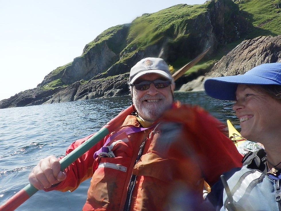
Amy and Nick between Garvellachs and Garb Eileach 2025. Nick said to Amy "Let's not use our paddles. Let's just see where the water takes us. Look, you can see a drop coming up." These smiles show how much fun and mischief that led to.
Since that day on St Kilda in 2019 I have, with Alan and pals, paddled round Isla, touched Jura (please, one day, I’d like to go back), slept on Scarba, Lungha, Rubha Fiola, skimmed Lunga, lunched on Dubh Mor, slept with the Saints on Eileach an Naoimh, coasted along below the Garvellachs with eagles floating above, hung out with the ghosts of slate miners on Balnahua. And more. Inspired by this day.
Once, rounding the Mull of Oa on the tip of Islay I was astonished to look south to the mountains of Ireland, so close you could touch them. I long to make that crossing one day. You don’t forget a moment like that. It stays with you.
Nick shows the how and the why and the water galloping down the fine alleyways from the Atlantic edge into the sounds. The sea bed, the fissures and gulleys and shelves of the rock below have their own part to tell: each alley is a unique experience in a kayak.
The Sound of Luing is always interesting. Whenever I have crossed from Luing to Lunga the water shivers and whirls mysteriously. It used to scare me but now my attitude is more playful. There are apps that would tell the whole story but I don't have one. There's always more to find out. How lucky to be 76 and still discovering.

As the flow ebbed the drop got bigger. Amy playing. Photo Alan Kimber
In the gap between Lunga and Fiola Meadhonach you get drops in level at certain stages of the tide. The water tumbles over and it feels like paddling a "sea river". Arrive too late on the ebb and you won't be able to get through. There are compensations for turning back: you can play awhile on the waves and enjoy watching the otters and seals watching you. This is their world. Sometimes an eagle will rise with a bigger fish than you'll likely see on a fishmonger's slab.
Paddling the sound between Isla and Jura is a gift. You just sit tight and let the smooth swift flow take you. Eddy out at Porth Askaig for a second breakfast at the friendly pub if you're so inclined -but don't leave it too late or you will have barrelled down too far.

Correyveckan maelstrom with tour boat. Glasgow Herald
By contrast, in the Gulf of Correyveckan, there is turbulence. The sea bed plunges to 200 metres with a pinnacle or wall of rock that rises to just 30 metres short of the surface. The effect of this on the water rushing through the gulf is the stuff of legends.

With thanks, Mike Buckley
The early Irish text Dinnseanchus decided that the Correyveckan whirlpool was “the confluence of many seas, each pouring itself into the place of the other, until they are swallowed down to the bottom, and until it is like an open cauldron, sucking and disgorging its draughts, so that its roaring is like distant thunder." That wasn't far off the mark.
In 1845, Archibald Sinclair had more graphic terms: "we must believe that there is a miraculous submaritime vortex that causes a constipation of billows so as to cause them to reverberate in the calmest of weather." (Gillies, in “Netherlorn. Argyllshire at its Neighborhood”).
In 2012 a survey by Christian Armstrong, a UHI PhD student, for the Scottish Association for Marine Science (SAMS), produced this graphic using high-resolution multibeam sonar, This gave "unprecedented insight into how the seabeds form and the tidal flows interact in dynamic equilibrium without yet solving the mystery of the Correyveckan."

The power of the whirlpool and its mystery still draws us in. The tourist boat tradition has continued since Victorian times, in powerful RIBs rather than sturdy woooden rowing boats.
Doctor Prosody was on a tour "in search of the Antique and Picturesque" 1821.
In 1949 Lt Colonel Arthur Murray went through with a party of friends. "Soon, on our left, not 200 yards from us, there began a wild tumbling sea, deep blue troughs and curling waves 10 to 20 feet high, all foam-topped, and this turmoil extended half a mile away from us and fully a mile alongside. The sea behind was quite calm; the Atlantic ahead lay asleep in the warm August sun; nothing to the eye to account for all this tumult so close at hand…
“What would happen if we got carried into that?” one of us asked the pilot.
“It would be certain death,” he replied emphatically; “no boat could live five minutes in it.” Then he added: “I never thought to see it so wild on a fine calm day, and a north wind.”
Neil and Amy went through a few years back. Lot of planning. Lot of advice sought. According to Amy’s account it was “really nice.” Neil said it was "alright". Neil is a bit of wind and wave whisperer mind you.
And now it’s July 2025 and the summer is long over. April was gorgeous, May was pretty good, June was good in parts. But that was then. The weather now is like a sulky toddler that can only draw breath between tantrums.
Amy, who has been working with Mark and Laura at Sea Kayak Oban has 5 days off. Neil has come up to join her, They are super kind enough to invite me along. I will be a lonesome peregrina no more. Amy and Neil always invite me over to their tent for coffee and I invite myself over in the evening with whisky. Lovely.

Morning coffee ritual with Amy and Neil. So lovely. Photo by Neil

Waiting for the Luing Ferry, photo Pen
We have two days and one night of rain and wind forecast followed by two, three if we’re lucky, half decent days. As Alan said, the Forth of Lorn is mighty hard to beat. Given the forecast, we would start with Luing, where the strings of islands to the west would protect us from the westerly wind and the swell that would have gathered and built over some 5 days of gales out over the Atlantic.

Neil on the ferry watching how the pilot uses the strong flow to manoeuvre the boat. We're on the edge of Cuan Sound here and no-one knows is better than these guys.
At Atlantic Islands Centre in Cullipool a band was booked, two lads from Glasgow touring the islands. The hall was packed. Some children were fronting the dancing. Mums, Dads and Grannies were at tables stacked with beers and the leftovers of fish suppers. The welcome was warm and uninquisitive. A lot of people pass through.

We came back for lunch. As well as excellent trip planning it is vital to refuel. Photo Neil
You need to know this: the food in the Atlantic Centre is fantastic. Did I mention the locally landed sea food? Upstairs the island’s local history collection is beautifully curated. There's a sofa on the first floor set in front of a big glass window, just right for reading and looking out to sea on a dreich day. Books provided. Who could ask for anything more?

The extensive abandoned slate quarries at Cullipool. tell their own story. Photo, Pen
The next day back over on the ferry and up to Arduaine. Excellent planning: on the outside edge of Luing the wind and swell are still battering and polishing the slate beaches. Here it is quiet, tucked in, with good enough protection from the wind and very little swell.

On Caisteal nan Con, Dog's Castle, Torsa. Tents below, photo by Pen
Over to Shuna, up Shuna Sound and then Torsa. In "Netherlorn" in 1909, Gillies describes Torsa as "a pleasant fertile single farm of 250 acres, good pasture for cattle and almost all land capable of cultivation." The runrigs of an earlier time are still visible. These strips were handed from croft tenant to tenant yearly at the will of the landowner. This was a disastrous system. No-one was motivated to toil to improve land that would only be theirs for a season and the natural fertility of Torsa fell away.
Next day we were up Seil Sound, eddy-hopping our way against the increasing flow south from Clachan Sound. We work our way up increasingly shallow eddies among lettuce green streamers of weed to just tuck under “The bridge over the Atlantic”.
A little drama in the steep rise of the cliffs to Dun Crutogain. On our right there are plenty of well kept houses on Luing. It’s almost tidy suburban. To our left a landscape carved out by the glaciers somewhere between 2.6 million and 22,000 years ago…it’s your choice. The rise is only around 270 metres but from a kayak at sea level that seems pretty high. Every now and then eagles float out on the thermals.

Bringing the boats across. I wanted to camp on the pebble tombola beach...but it was a bit of a gamble to pitch just above the sea line. I decided the line of dried out crunchy seaweed marked high water from a few days previously. Good planning that woman!

Neil and Amy on the beer. See that fire? There was no trace of it when we left. Of course!
Zapping back south with the flow we had a magical “silly” camp on Eileach Gammna, a tiny tombola island that changed its shape radically with the flood tide.

Silly camping? I'm told that if ever Neil has had a really bad day he takes a look at this photo. Can't imagine why.
Amy and Neil both had to get back to work. I did not and the forecast for the next three days wasn’t good, but it wasn’t bad either. I decided to take the next ferry out of Oban, wherever that was going.
Another two islands slept on: Torsa, Tombolo aka Eilean Gamha. Shuna, Rubha nan Ron and Tombolo paddled round means £23 donated to Aban, the charity that makes outdoor adventure possible for an increasing number of young people.


Aww...that was a great moment, beginning of a very memorable trip. I really hope to be with you in May, that's for sure.
Another fine set of photos and stories Pen. Let's add to them in May on Mull. See you all soon.